Contents [hide]
Intro
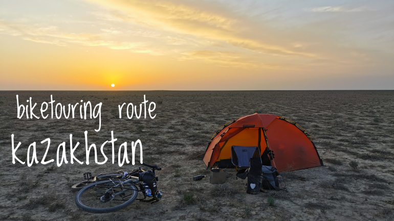
Biketouring route description for Kazakhstan covering the roads from Kuryk to Beyneu via Beket-Ata with a crossing of the Ustyurt plateau and from Almaty to Zharkent cycling over the Assy Plateau. The article includes GPX files and an interactive map with points of interest.
GPX files
Route stats
- Distance (km): 1193
- Total ascent (m): 6260
- Road days: 17
- Highest point (m): 2580
- Time of year (month): May (section 1) and August (section 2)
- Navigation app used: Mapy.cz
Highlights
My favorite highlights from Kazakhstan. Consider visiting these on your tour.
- Beket-Ata
- Crossing the Ustyurt Plateau
- Assy Plateau
Map with Points of Interest
The map contains points of interest (POI) on the route I cycled. Click on the marker for a detailed description. The list of POIs include places where you can eat, sleep, stock up on water and more. It also shows you where to buy a SIM card and other useful stuff.
The POIs were correct as of August 2023 so take this into consideration when you plan your own travels. Things change fast in this dynamic world. As always, I’m happy to receive feedback if any of the info given is not correct or up to date.
Section 1: From Kuryk to Beyneu via Beket-Ata and onwards to the Uzbekistan border
- Route: From Kuryk to Beyneu via Beket-Ata and onwards to the Uzbekistan border
- Distance (km): 604
- Elevation (m): 1.170
- Highest point (m a.s.l): 323
- Days: 8
From Kuryk to Zhanaozen: I arrived at the ferry terminal at Kuryk. This is a relatively new port. Before the ferry docked in Aktau. If you want to avoid cycling through busy Aktau it works to your advantage but if you want to have some big city infrastructure setting up a SIM card and getting some supplies other than food and water, this is clearly a disadvantage. Kuryk is a small town where you will find a supermarket and a hotel and not so much else. The ferry arrived late in the afternoon so I took a night at Hotel California in town to get organized before heading onwards. I bought a SIM card from the supermarket. Since there are no official mobile operator shops in town, I had to manage my own registration via their application (it can also be done via USSD codes) which only exist in Russian or Kazakh.
The road from the ferry terminal to Kuryk town is a short ride only taking an hour or two. Shortly after leaving Kuryk the paved asphalt road turns to a bumpy gravel road with washboard surface in many places. It makes for a very slow ride. There are no shops before you get close to highway A34 so you need to stock up in Kuryk. While I was there in May 2023 a new asphalt road was being built which I believe will connect Kuryk with A34. Only a small section of it was completed. Very little traffic passes by on these roads. This might change once the new asphalt road is complete. If you bike this stretch in the summer months you will not find any shade so be prepared for dealing with blazing hot sun and bring extra water (you need more than you probably think).
Just before A34 you’ll get a couple of markets where you can get water and basic food supplies. There are no cafeterias or gas stations on A34 until you reach Zhanaozen so this is the place to get what you need for the road. Winds seem to be a constant thing on these very flat roads. You might need an extra day to reach Zhanaozen if you have a strong headwind.
Scenery along the road quickly gets boring if you are not into flat steppe landscapes. To sweeten the deal, you will see plenty of horses running wild which is a beautiful sight. There are also loads of camels grazing along the road. If you plan to camp in storm flood tunnels under the road to take cover for wind and sun then think twice. Horses have also figured out that these hidden camp places are a great place for a rest.
I only cycled around Zhanaozen and ate lunch at a cafeteria on the outskirts so I can’t say much about the city itself. The cafeteries are a bit hidden if you don’t know how to read their cyrillic letters. Very practically they only have a sign on top of the building with text telling what they are and no other visual means to let you know they are selling food. It took some time to recognize the eateries which there are not many of.
From Zhanaozen to Beket-Ata: Leaving Zhanaozen you pass through a bleak industrial area with vintage looking oil pumps. It’s not pretty to look at but in some way it becomes a bit fascinating staring at the endless rows of electrical wire on wooden posts and oil pumps that look just like the ones from last century United States (I guess the pumps are modern enough they just have a timeless and flawless design with no need for improvements). In Qizilsay you can find water and snacks in a grocery store. This is your last option for water before reaching Shopan-Ata.
After Qizialsay the emptiness begins. Kazakhstan is a very big country area wise. It is not densely populated at all and you get to feel it once you leave this last frontier of Zhanaozen. The road from Qizilsay to Beket-Ata is in excellent condition as of 2023. No shoulder but very little traffic. Basically the only cars driving here are the ones visiting the pilgrim sites of Shopan-Ata and Beket-Ata and tourist 4WDs touring the landscape.
You can reach Shopan-Ata in one day from Zhanaozen. It’s an underground cave mosque visited by locals from far and wide. There’s an option to sleep in the common rooms which can fit hundreds of people. They have no mattresses so unless you want to sleep on the floor roll out your own sleeping pad. Once you have arrived you will be invited for tea and snacks. At night you will have a hard time to avoid joining the common dinner which will be the traditional dish of Kazakhstan with square noodle plates and meat served on a large communal plate.
Another day’s ride and you will be at Beket-Ata. From Shopan to Beket the landscape becomes more interesting with sparse rock formations appearing proving that Kazakhstan is more than just a very big and wide steppe. At a scenic viewpoint I was told I was looking at the Tiramisu mountains because they looked like the dessert (I couldn’t see the resemblance but perhaps you can). If you got the time for it, it’s recommended to take a detour to see the Boszhira mountains. At Beket-Ata you have the same set up as Shopan-Ata with free tea and snacks.They also serve free dinner throughout the day. You can sleep in the common rooms.
From Beket-Ata to Beyneu: No more smooth paved asphalt road. Ahead is a long stretch of gravel road across the steppe. The gravel road is not too bad. No rocks and no washboard surface. Mostly even and hard packed. I was here when the surface was all dry but I guess this road is best avoided when it has just rained or rain is forecasted. It can easily turn into a mud bath. There is a long and short version of the gravel road. Long version ends at Tolep and the short one at Say-Otes (I’ve marked the location where the gravel road splits as a POI in the map above). I went for the long version and don’t know about the condition of the gravel road leading to Say-Otes. Until you reach the A33 highway you are all alone on the steppe. Perhaps one car will pass a day. There is no cell phone connection so be sure to tell people about your whereabouts and bring enough water for a bike emergency where you in worst case will have to walk back to Beket-Ata or walk to the highway. Actually you are not completely alone. I passed a couple of farms with a car parked outside. But they were far away and I couldn’t see any people. However, they can act as a point of rescue if you need it. Just take your precautions beforehand so you can enjoy the feeling of an empty world while you cycle this great steppe. I like landscapes that are endless nothingness and being able to pitch my tent in absolute silence and solitude, but perhaps you might want to consider if you will find such a landscape utterly boring before embarking on a +100km long gravel road.
Once you reach the A33 highway you just have more of the same scenery but now with light traffic on an asphalt road. A narrow shoulder is there and the asphalt condition is OK. Traffic is considerate and gives you good clearance and space but be aware of strong side winds pushing you onto the road. There are no gas stations or places to get water and food along the road before you reach Beyneu. I had to cycle 10ish KM back and forth on a bumpy sideroad to the highway to reach a small village called Tolep which is located close to where the gravel road meets the highway. Here I started knocking doors to get someone to open the small grocery store where I bought water and snacks. If Tolep fails on you, there is no water supply until Beyneu. Either you count on Tolep or you bring enough backup water to reach Beyneu. Or you flag down truck drivers and kindly ask for some water (you probably won't have to wait long as the drivers here usually carry a lot of water). Tolep to Beyneu is rather uneventful. From Beket-Ata you need 2 to 3 days to reach Beyneu. Take a well deserved rest in Beyneu before heading to Uzbekistan.
From Beyneu to the Uzbekistan border: Leaving Beyneu for the border highway goes quickly. The road to the border on the Kazakhstan side is in really good condition and with a narrow shoulder. There are no shops along the road before the border so bring water and snacks for one day. Crossing the border into Uzbekistan should be doable the same day as leaving Beyneu. You'll pass several pavilions on the way to the border. These are good for a rest and some shade or cover for rain. Next to the pavilions are very primitive pit toilets which are basically just a hole-in-the-ground toilet. Very basic and very smelly but they do offer privacy which is difficult to find on the open and flat steppe. There are no doors on the pit toilet so be creative with an "occupied" sign if you are a solo traveler.
On the Uzbek side of the border there are a couple eateries and a shop where you can buy water. There are also hotels on each side of the border but they were either full or too expensive (+20 USD) so I didn't try them out myself. I camped 12 km away from the border on the Uzbek side.
On a general note, finding a wild camp spot in Kazakhstan from Kuryk to Beyneu is not difficult. You have a big open steppe as an option everywhere you go as long as you are outside of any town or city. The ground is solid enough for good anchoring of the tent. Always anchor your tent in Kazakhstan. Heavy winds pick up quickly. You will have a hard time hiding your tent but it's possible if you are willing to spend some time leaving the road. I did not have any issues sleeping in my tent visible from the road. All that happened was some random visits from curious farmers that just wanted to wish me a good night's sleep.
Section 2: From Qorday to Zharkent via Assy Plateau and onwards to the Chinese border
- Route: From Qorday to Zharkent via Assy Plateau and onwards to the Chinese border
- Distance (km): 589
- Elevation (m): 5090
- Highest point (m a.s.l): 2580
- Days: 9
From Bishkek to Almaty: This stretch is urban riding out of Bishkek on busy roads to the border between Kyrgyzstan and Kazakhstan. It was a very quick border crossing. No x-ray or opening of panniers. It was just stamping my passport on both sides of the border and then I was through. The rest of the way is just a main road with a standard flat landscape. I camped at a lake the first night and woke up the next morning with loads of local hobby fishermen close by who came early morning to catch some fish. The next day I camped next to a highway fence and did not have much of a good night’s sleep. Much of the road here is fenced off but you can look for entry points close to the drainage tunnels if you want to sleep on the other side of the fence and away from the busy road. Highlight of this stretch was the mountain backdrop to Almaty which you could see when you got close enough to the city.
Cycling into Almaty was not too bad. For the most part on the main roads from Bishkek I had a narrow hard shoulder and when the shoulder disappeared there was a soft gravel shoulder. Into Almaty I went on sidewalks or official cycle paths.
From Almaty to Zharkent via the Assy Plateau: There is one day of cycling to get to the base of the Assy Plateau climb. It was urban riding for most part of the day on similar roads as from Bishkek to Almaty. After Türgen you reach an entrance gate where I had to pay 545T for a ticket. From the gate there’s one day of climb where you get the first part on asphalt and then the last part on gravel until you reach a mini plateau. Here you will see a larger settlement of yurts and tents looking like a theme park in nature where kids go on merry horse rides and families play sports and do picnics and race on Quad bikes.
After the theme park camp there is a long, more or less flat road leading up to the last set of switchbacks to the pass and the star observatory. When you have cycled over the pass you will be on the massive Assy Plateau. It was busier than I thought with yurts, houses and loads of animal herds. You can cycle across the plateau in one day but I recommend spending longer. From the plateau you have some challenging climbs and descents on bad gravel roads until you reach Bartogay Lake. Longer parts of the descent is really just a mix of larger stones, mountain rock and coarse loose sandy gravel. I didn’t cycle much of this and I ended up pushing the bike on the hills and walking it down on the descents. I did the Assy Plateau when it rained a lot so the gravel roads were really slippery. But pushing and walking the bike aside, you descend into a really really beautiful valley with patches of trees, various shades of green and bare rock all making this a wonder to look at.
At the end of the Assy Plateau you will reach Bartogay Lake. You can camp here if you like or continue around the lake to an asphalt road leading to Kökpek where you will find a mini-market and a restaurant.
If you are heading to Zharkent and the Khorgas border with China, you can do a 50ish km detour to the Charyn Canyon. Be warned that scores of tourists arrive in bus loads and can make the whole experience rather busy. If you go to Charyn Canyon or not, you will have two days to reach Zharkent on similar roads as the one getting you to Almaty. Just some long main road stretches with a narrow hard shoulder. On the plus side, the traffic is really not so busy here.
In Zharkent, you catch a border bus taking you and your bicycle across the border to China. I have not heard of anyone doing the crossing on a bicycle but neither have I heard of any trying. They all took the bus so I did the same.
biketouring south korea
2023-08-04 | blog
Biketouring journal covering South Korea and the roads from Seoul to Busan with a detour to Jeju Island and looping back north to Sokcho and the DMZ. I cycled the
entire set of certified bike paths which were The Cross Country, The 4 Rivers and ...
biketouring route mongolia
2023-10-12 | itinerary
Biketouring route description for Mongolia covering the roads from Khovd Aimag to Zamiin-Udd via Ulaanbaatar including GPX files and an interactive map with points
of interest.